
728x90
SMALL
지도 클릭 이벤트는 map.on('singleclick', function(evt) {...}를 사용하면 된다
나는 그 안에 맵의 pixel정보들을 확인해서 layer와 coordinate를 넘겨주었다
viesResolution을 가져오고, url도 설정해준다
feature의 정보를 알고싶을 때는 layer.getSource().getGetFeatureInfoUrl을 쓰면 된다
info-fommat은 text/html도 되지만 난 ajax를 사용해 값을 넘길거니 json형태로 변환해준다
그리고 자꾸 뭔가 xy값을 못가져오길래 xy좌표를 replace해주는 함수도 추가해줬다
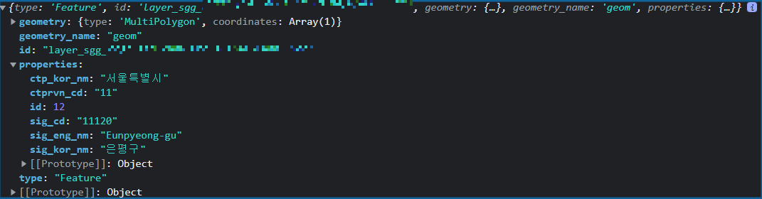
해당 url로 넘기면 data.features[0].properties에서 값을 확인할 수 있다
해당 소스
//epsg_cd값 설정
var epsg_cd = 'EPSG:3857';

//map클릭했을 때 이벤트
map.on('singleclick', function(evt) {
    map.forEachLayerAtPixel(evt.pixel, function(layer) {
            showLayer(layer, evt.coordinate); //layer와 coordinate넘기기
        });
}

function showLayer(layer, coordinate) {
var viewResolution = /** @type {number} */ (map.getView().getResolution());
		//featureInfoUrl설정
        var url = layer.getSource().getGetFeatureInfoUrl(
            coordinate, viewResolution, epsg_cd,
            {
                'INFO_FORMAT': 'application/json',
                'VERSION': '1.1.1',
                'FEATURE_COUNT' : 10,
            }
		);
		url = changeXY(url);

    //ajax를 통해 feature값 가져오기
	$.ajax({
		url : url,
		dataType : "json",
		success : function(data) {
			//console.log(data.features[0]);
			var value = data.features[0].properties.sig_cd;
       		 }
        });
	}

//좌표 X Y변환
	function changeXY(url){
		url = url.replace("I=", "X=")
				 .replace("J=", "Y=");

		return url;
	}
참고한 ref는 아래
https://openlayers.org/en/v4.6.5/examples/getfeatureinfo-image.html
WMS GetFeatureInfo (Image Layer)
This example shows how to trigger WMS GetFeatureInfo requests on click for a WMS image layer. Additionally map.forEachLayerAtPixel is used to change the mouse pointer when hovering a non-transparent pixel on the map.
openlayers.org
728x90
LIST


댓글